

Kühtai - Pockkogel

Difficulty
moderate
Ascent
3h
Route length
8.5 km
Uphill
830 m
Town
Kühtai
Learn more
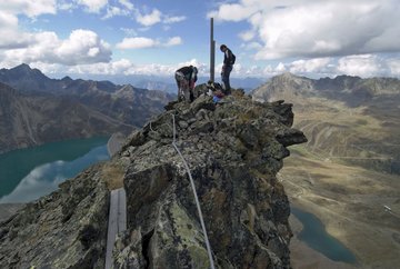
Opposite the tourist information, follow the marked path up Wiesberg to the Drei-Seen-Hütte. The path is well marked and offers hikers beautiful views of the Stubai Valley and the surrounding mountains. From the Drei-Seen-Hütte, continue towards the dam of the Finstertal reservoir. Initially, stay on the lower path above the lake, providing a fantastic view of the water and surrounding nature. After about 300 meters, the trail to Pockkogel, marked with P.K., branches off to the left. This trail leads to the Steintalsattel and from there, in less than half an hour, to the summit of Pockkogel.
To get back to the starting point, hike back along the same route.
To get back to the starting point, hike back along the same route.
Further information
Tour
Difficulty
moderate
Uphill
830 m
Downhill
830 m
Highest point
2.807 m
Ascent
3h
Route length
8.5 km
Information
Walking time total
5h
Descent
2h
Starting point
Tourist information Kühtai
End point
Pockkogel
Arrival
- Line 4166 - Regiobus Sellraintal
Line 4196 - Regionalbus Oetz - Ochsengarten - Kühtai
Seals of Approval
Tyrolean hike medal


